The gazetteers and directories are a rich source of information on a specific moment in the geography of historical cities, linking the distribution of space with socio-economic or professional data. One of the most famous among them, the Annuaire-Almanach du commerce Didot-Bottin, is now accessible on Gallica. But there are other socio-professional or social directories (such as Tout-Paris, Paris-mondain) that remain buried in library collections without having been fully exploited until now. The Paris Time Machine consortium is interested in this type of source and is particularly interested in making accessible and searchable the “Annuaire des propriétaires et des propriétés de Paris et du département de la Seine”, an annual publication that was active between 1894 and 1937.

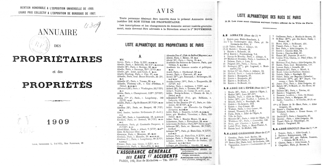
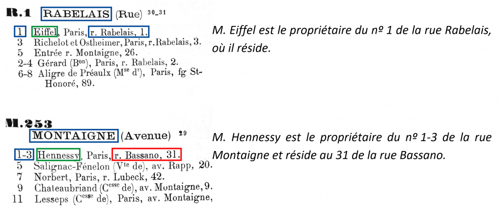
This directory lists all Parisian addresses and their owners and is composed of two main sections (see figure 1). The first part of the book includes an alphabetical list of all the owners of Paris and all the properties in Paris, grouped by owner. The second part contains a list of the streets of all the properties in Paris with the name and personal address of the owner. This list specifies whether the owner’s residence is in Paris, in the provinces or abroad. From the study of this last section, we observed six possible cases for each address: 1) owner’s domicile, 2) property(ies) belonging to a person (titles of nobility and certain professions are indicated), 3) property(ies) managed by third parties, 4) property(ies) of the city of Paris or the State (buildings, industrial buildings), 5) seat(s) of a private company or a public service, and 6) other building entries.

The mass of data to be recovered (approximately 40,000 owners per volume) requires working with an information extraction system capable of structuring the digitised resources using a machine learning model. We are therefore developing a digital directory processing and analysis chain. We aim to render the set of four editions (1898, 1903, 1913, 1923) in several formats (XML Alto, XML/TEI, spreadsheets). This will allow historians to query and analyse them automatically and in a massive way. It would be possible, for example, to extract owner information (individuals, public) from these sources. Thanks to geographic information systems (GIS), it is possible to geocode these addresses based on a geographic (and historical in the best of cases) reference, to project them on a map and to study them diachronically, to cross-reference them with other geolocalised data on Paris and on the same period.
The data and source code produced as part of this work will be released under an open-source license. For more information: https://github.com/PSIG-EHESS/PTMAnnuaires/
Team members
Gabriela Elgarrista (Plateforme Géomatique EHESS, ENC)
Frédérique Mélanie-Becquet (LATTICE)
Carmen Brando (Plateforme Géomatique EHESS)
Alix Chagué (Inria-ALMAnaCH)
Mohamed Khemakhem (Inria-ALMAnaCH)
Laurent Romary (Inria-ALMAnaCH)
Jean-Luc Pinol (ENS Lyon)
Bibliographical references
Cura, R. , Dumenieu, B., Abadie, N., Costes, B., Perret, J., Gribaudi, M. (2018). Historical collaborative geocoding. ISPRS International Journal of Geo-Information. https://arxiv.org/abs/1703.07138
Di Lenardo, I., Barman, R., Descombes, A., Kaplan F. (2019). Repopulating Paris: massive extraction of 4 Million addresses from city directories between 1839 and 1922, Digital Humanities conference DH2019, Utrecht, Pays-Bas, https://dev.clariah.nl/files/dh2019/boa/0878.html
Khemakhem, M., Brando, C., Romary, L., Mélanie-Becquet, F., Pinol, J.-L. (2018). Fueling Time Machine: Information Extraction from Retro-Digitised Address Directories. JADH2018 “Leveraging Open Data”, Sep 2018, Tokyo, Japan. https://hal.archives-ouvertes.fr/hal-01814189
Pinol, J.-L. (2009). Les atouts des systèmes d’information géographique – (SIG) pour « faire de l’histoire » (urbaine). Histoire urbaine, 26(3), 139-158. doi:10.3917/rhu.026.0139.

